


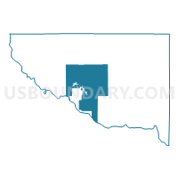
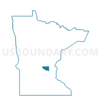
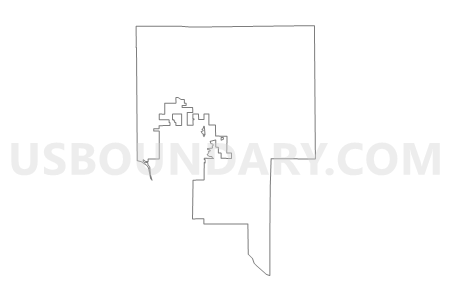
Becker Twp. Voting District, Sherburne County, Minnesota
About
Outline

Summary
| Unique Area Identifier | 604381 |
| Name | Becker Twp. Voting District |
| County | Sherburne County |
| State | Minnesota |
| Area (square miles) | 53.91 |
| Land Area (square miles) | 53.38 |
| Water Area (square miles) | 0.53 |
| % of Land Area | 99.02 |
| % of Water Area | 0.98 |
| Latitude of the Internal Point | 45.41370340 |
| Longtitude of the Internal Point | -93.83531600 |
Maps

Graphs
Select a template below for downloading or customizing gragh for Becker Twp. Voting District, Sherburne County, Minnesota


Neighbors
Neighoring Voting District (by Name) Neighboring Voting District on the Map
- Becker City Voting District, Sherburne County, MN
- Big Lake Twp. P-2, Sherburne County, MN
- Big Lake Twp. P-3, Sherburne County, MN
- Blue Hill Twp. Voting District, Sherburne County, MN
- Clear Lake Twp. Voting District, Sherburne County, MN
- Monticello Twp. Voting District, Wright County, MN
- Orrock Twp. Voting District, Sherburne County, MN
- Palmer Twp. Voting District, Sherburne County, MN
- Santiago Twp. Voting District, Sherburne County, MN
- Silver Creek Twp. Voting District, Wright County, MN
Top 10 Neighboring County Subdivision (by Population) Neighboring County Subdivision on the Map
- Big Lake township, Sherburne County, MN (7,386)
- Becker township, Sherburne County, MN (4,842)
- Becker city, Sherburne County, MN (4,538)
- Orrock township, Sherburne County, MN (3,451)
- Monticello township, Wright County, MN (3,181)
- Palmer township, Sherburne County, MN (2,354)
- Silver Creek township, Wright County, MN (2,335)
- Blue Hill township, Sherburne County, MN (2,176)
- Santiago township, Sherburne County, MN (1,895)
- Clear Lake township, Sherburne County, MN (1,539)
Top 10 Neighboring Place (by Population) Neighboring Place on the Map
Top 10 Neighboring Unified School District (by Population) Neighboring Unified School District on the Map
- St. Cloud Public School District, MN (96,237)
- Monticello Public School District, MN (20,466)
- Princeton Public School District, MN (20,347)
- Big Lake Public School District, MN (17,276)
- Becker Public School District, MN (11,437)
Top 10 Neighboring State Legislative District Lower Chamber (by Population) Neighboring State Legislative District Lower Chamber on the Map
Top 10 Neighboring State Legislative District Upper Chamber (by Population) Neighboring State Legislative District Upper Chamber on the Map
Top 10 Neighboring 111th Congressional District (by Population) Neighboring 111th Congressional District on the Map
Top 10 Neighboring Census Tract (by Population) Neighboring Census Tract on the Map
- Census Tract 304.02, Sherburne County, MN (9,292)
- Census Tract 304.04, Sherburne County, MN (8,983)
- Census Tract 304.03, Sherburne County, MN (8,924)
- Census Tract 302, Sherburne County, MN (7,224)
- Census Tract 303, Sherburne County, MN (5,929)
- Census Tract 1002.03, Wright County, MN (5,568)
- Census Tract 1003, Wright County, MN (5,376)